Floor plan at a glance
| Total area | 11 hectares |
| Central building | 214 × 110 metres |
| Main halls | Frigidarium, Tepidarium, Caldarium, Natatio |
| Underground sections | Mithraeum + service galleries (6 km) |
| Visitor entrance | Viale delle Terme di Caracalla 52 |
| Exit | Same side (loop route) |
The complex layout
The Baths of Caracalla develop along a symmetrical north-east / south-west axis. The central building is a rectangle of 214 × 110 metres surrounded by a large enclosure of 350 × 350 metres (gardens, external gymnasiums, libraries, cisterns).
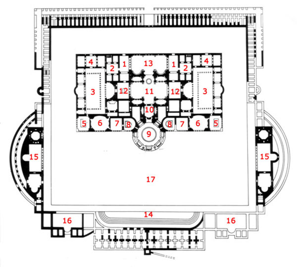
The visitor enters from the north-east, crosses the access gardens, reaches the bathing building, traverses it lengthwise and returns to the starting point. The complete route is about 1.2 km.
Main halls in detail
Frigidarium — The cold hall
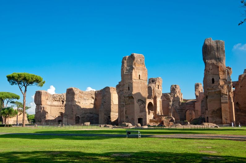
The frigidarium was the largest covered interior of ancient Rome: 58 × 24 metres, 41 metres high with groined vault ceiling. Four large cold basins occupied the corners. It was the main passage point between different climate zones. Today the roof is gone, but the lateral walls stand intact.
Natatio — The open-air swimming pool
The natatio was a grand rectangular open-air pool (50 × 22 m), surrounded by monumental columns. Three niches on each side held colossal statues. The Farnese Bull and Farnese Hercules, now in the Naples Archaeological Museum, came from here.
Tepidarium — The warm hall
A transitional space between cool and hot. Smaller than the frigidarium, it functioned as an adaptation chamber. Floor and walls were moderately heated using the hypocaust system.
Caldarium — The heated rotunda
Heart of the complex, the caldarium rotunda measured 35 metres in diameter and reached 44 metres high. The dome has partially collapsed, but the circular wall with seven large south-west-facing windows survives to capture afternoon sun. Central basin of hot water, heated by underground furnaces.
East and west gymnasiums
Two symmetrical spaces for physical exercise. Each was preceded by an open peristyle with geometric mosaic flooring, partly still visible.
Underground Mithraeum
Rome's largest Mithraeum (23 × 9 m), dedicated to the Persian god Mithras, sits below the frigidarium level. Visits by request or in specific guided tours only: steep stairs, no wheelchair access.
Service galleries
Below the entire building runs a network of 6 km of galleries, up to 6 metres high, traversed by hundreds of slaves managing furnaces and transporting firewood. Partially visitable during special openings.
Suggested route (90–120 minutes)
- Entry and ticket office (5 min)
- Outer gardens and west gymnasium (10 min) — see in-situ athlete mosaics
- Frigidarium (15 min) — the most imposing hall, stand at its centre for perspective
- Tepidarium (5 min) — brief passage
- Caldarium (15 min) — enter the rotunda, look up
- Natatio (15 min) — the open pool, best photos from the south-east
- Mithraeum (15 min, optional, steep stairs)
- East gymnasium and outer mosaics (10 min)
- Gift shop and exit
Best viewpoints and photo spots
- Frigidarium centre: axial view of the lateral walls, human figure for scale
- North-east corner of frigidarium: overlapping arch play
- Caldarium from outside (south-west): the rotunda against sky, ideal at sunset
- Natatio: shot along the surviving columns
- South side of outer enclosure: century-old pines and walls, "romantic" shot
- Gymnasium mosaics: close-up detail of athlete figures
Practical facilities map
- Ticket office: just past the gate, on the right
- Gift shop: near exit, on the left
- Public toilets: two blocks, at entrance and mid-route
- Audio guide rental desk: next to ticket office
- VR stations: three points inside the central building
- Water dispensers: two, near entrance and east gymnasium
- Benches: scattered in gardens, few inside the building
- Rubbish bins: only in outer gardens
Accessibility
The main route is wheelchair-accessible. Non-accessible areas:
- Underground Mithraeum (steep stairs)
- Service galleries (occasional visits, uneven ground)
- Part of the south side (deep gravel)
At the entrance, a tactile map for visually impaired visitors is available, with Braille labels and embossed main halls.
Maps and additional materials
- Paper map: free at entrance, in 5 languages
- PDF map: downloadable from turismoroma.it
- Audio guide app: includes interactive geo-located map
- Google Maps: the exterior site is already mapped
- Historical map: reconstructions by archaeologist Spinazzola displayed in main halls
Frequently asked questions
- Is there an official printable map?
- Yes, downloadable as PDF from turismoroma.it.
- How long does the complete route take?
- 90–120 minutes for the standard visit. With VR and Mithraeum, up to 3 hours.
- Is the exit on the same side as the entry?
- Yes, the route is a loop with exit near the entrance.
- Can you climb the walls?
- No, access to walls is restricted for safety.
- Are the halls clearly signposted?
- Yes, multilingual information panels in the main halls.
- Does the map change often?
- Very little: some halls open or close for restoration, and the Mithraeum isn't always accessible.
Ready to visit?
With map in hand and ticket in pocket, your visit flows smoothly. Book online and head straight to the turnstile.